Research Paper
The effects of spatial resolution on rooftop photovoltaic detection in satellite imagery
Husnain KhurshidNational University of Sciences and Technology, Islamabad
Preprint · in preparation
Abstract
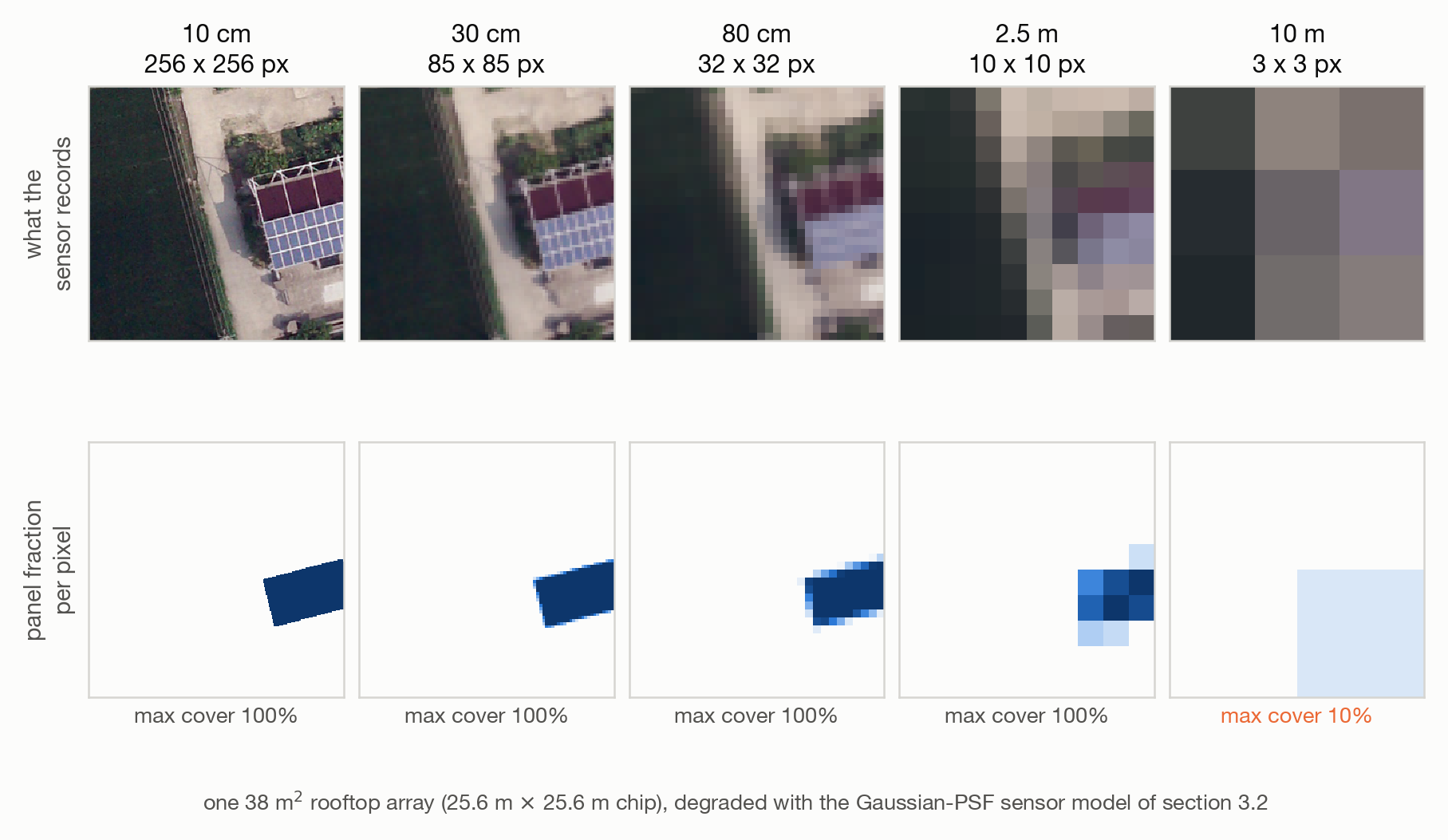
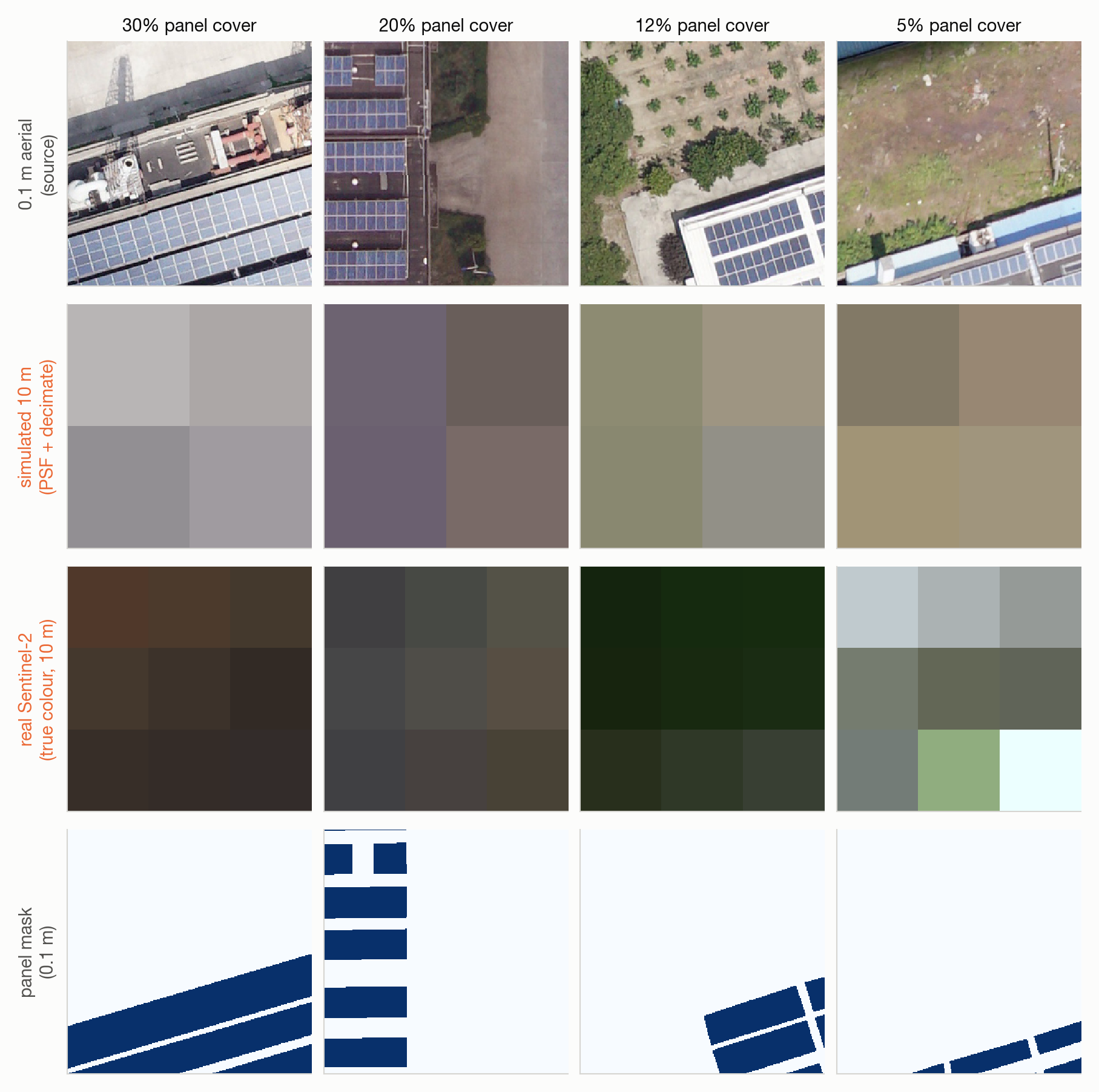
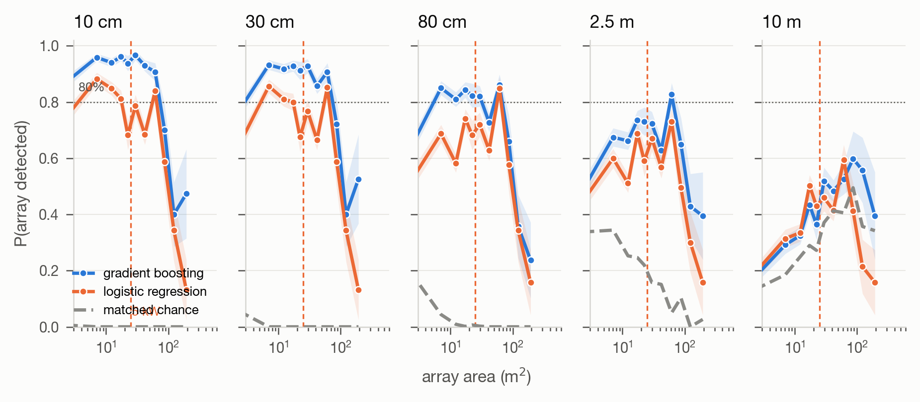
Rooftop photovoltaic detection is reported at ground sample distances spanning two orders of magnitude, but no study isolates resolution as a variable: comparisons change the sensor, the scene and the geography together, so no number from one paper is commensurable with another. We hold the scene fixed and vary only resolution, degrading 0.1 m aerial orthophotos of 645 rooftops through a point-spread-function sensor model to 0.3, 0.8, 2.5 and 10 m, and evaluating four detector families at every rung under identical spatially blocked cross-validation. We then acquire real Sentinel-2 over the same rooftops to test whether the simulation is faithful.
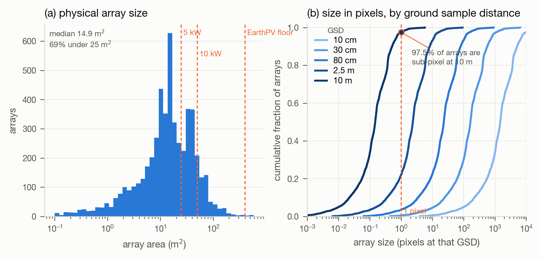
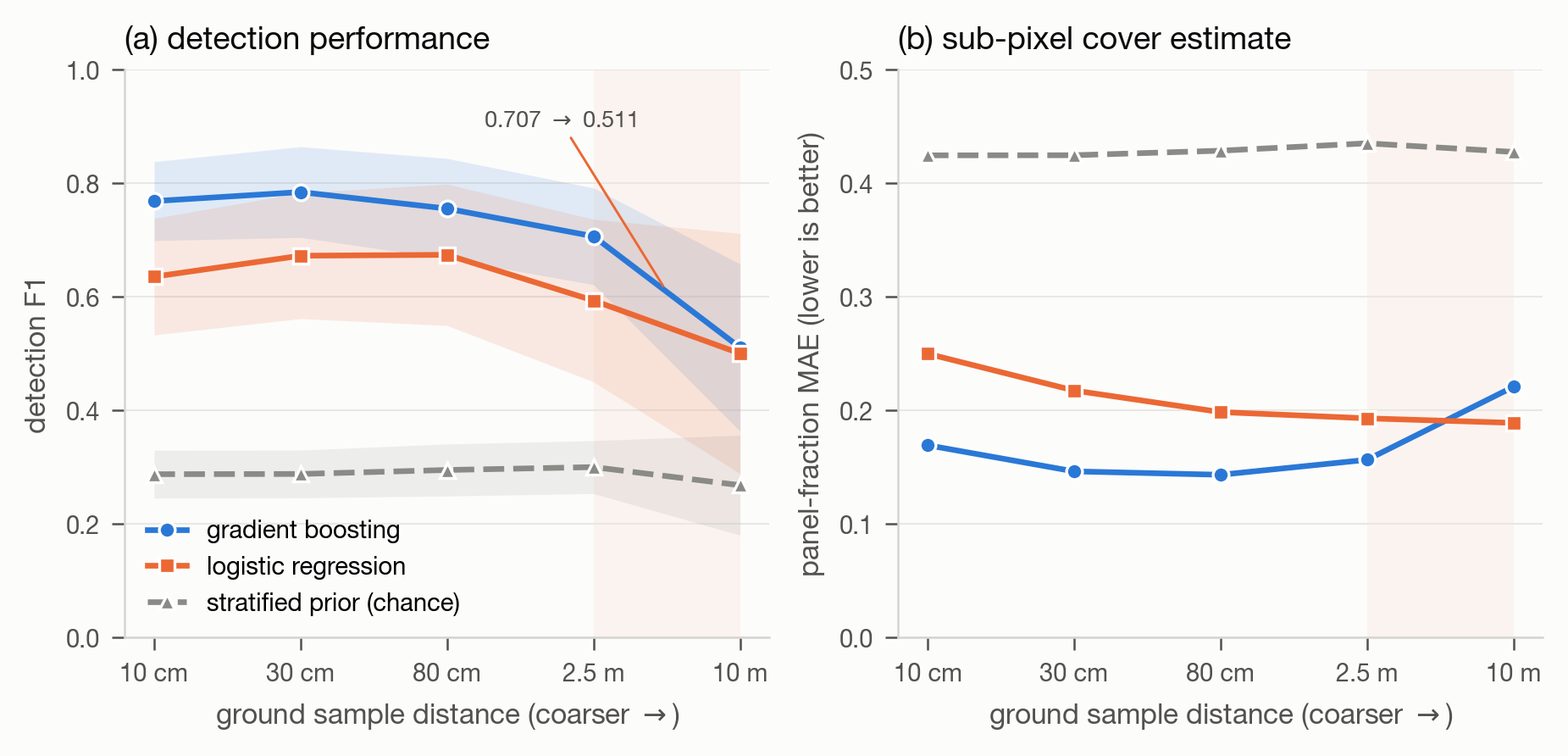
Four results follow. First, and most consequential for the field, random cross-validation inflates chip-level R² by a factor of 22 on this data (0.699 ± 0.047 random, 0.032 ± 0.440 spatial) because overlapping chips place the same rooftop in training and test; the evaluation protocol dominates every other design choice we measure. Second, 97.5% of arrays are smaller than one Sentinel-2 pixel, and three-band imagery at 10 m has no predictive power for panel fraction whether the three bands are simulated or real (R² ≈ 0 in both cases). Third, spectral breadth substitutes for spatial resolution at 10 m: moving from three bands to twelve buys +0.275 R², more than any change in resolution we measure. Fourth, spatial context becomes more valuable as resolution coarsens, not less — a small convolutional network matches per-pixel colour classifiers above 0.8 m but exceeds them by 0.05–0.06 F1 at 2.5 and 10 m.
We report detection floors as curves against array area rather than as a single threshold, alongside a matched chance baseline that the conventional per-array detection criterion fails to beat.
What We Found
Random cross-validation inflates R² by 22×
0.699 under random folds, 0.032 under spatial folds — same data, same model. Overlapping chips put the same rooftop in train and test. The evaluation protocol dominates every other design choice measured here.
At 10 m, band count beats spatial resolution
Going from 3 bands to 12 buys +0.275 R². No change in spatial resolution we measured buys as much.
97.5% of rooftop arrays are sub-pixel at 10 m
Median array 14.9 m²; 69% fall below 25 m² — the size of a 5 kW domestic system.
Three-band imagery at 10 m has no predictive power
R² ≈ 0 whether the three bands are simulated drone RGB or real Sentinel-2 visible.
Figures
Data
- Jiang et al. (ESSD 2021), PV01
645 chips of 0.1 m UAV orthophoto over Jiangsu, China; three roof types; 5,238 annotated arrays. CC-BY-4.0, via Zenodo.
- Sentinel-2 L2A
Real acquisitions over the same rooftops, via Element84 Earth Search over the public sentinel-cogs bucket — no credentials required.
Limitations
Research prototype. These findings rest on one dataset over a single 7×17 km area on a single date; the direction should generalise, the magnitudes should not be quoted as universal. The method axis currently covers per-pixel colour baselines and a small CNN — no promptable-segmentation rows yet.
Cite this work
@article{khurshid2026resolution,
  title  = {The effects of spatial resolution on rooftop photovoltaic
            detection in satellite imagery},
  author = {Khurshid, Husnain},
  year   = {2026},
  note   = {Preprint}
}